 Most ranch cowboys have an innate sense of direction. Duke Beardsley (left) and Duke Phillips (right) share more than the same name. They both have passion for the ranching lifestyle and preserving it.
by Jennifer Denison
A Western Horseman editor must have a skill set that exceeds what many people would expect. Obviously, we are hired for our journalistic and photography abilities, as well as our knowledge of the stock horse industry. However, there are some things we are expected to do that aren’t taught in journalism school. One of these skills is reading road maps—not the paper atlases published by Rand McNally, but maps drawn in the dirt with a stick by a rancher, or directions explained using natural landmarks.
On a recent trip to Chico Basin Ranch, about 30 miles southeast of Colorado Springs, Colorado, I realized just how important it is to have this skill. I was at the ranch to photograph artist Duke Beardsley for an article that will appear in the January 2015 issue. Beardsley enjoys stepping out of his studio and into the saddle at Chico Basin as often as possible to take photographs that inspire his paintings and to stay connected to the lifestyle in which he was raised.
 An autumn sunrise on Chico Basin Ranch in southern Colorado is worth getting up before dawn to see.
As much as I prefer riding out with ranch crews and taking photos along the way, in some situations it makes more sense to drive to remote pastures, scout a good location to set up and be ready to get the shots. It saves wear-and-tear on equipment, allows me to use more camera gear, and often gives me more control of the setting to ensure I capture the images needed.
That fall morning at Chico Basin, ranch manager Duke Phillips gave me directions to a line cabin where he and his crew would meet me before riding out to gather cattle and move them to a new pasture. Since there aren’t mile markers or street signs on the ranch, Phillips, like most ranchers I work with, gave directions using landmarks such as rock formations, forks in the road and an old corral. It was before dawn on the morning of the Blood Moon lunar eclipse, and I was a little concerned about missing one of these landmarks and getting lost on the 87,000-acre outfit. However, Phillips was very specific with his reference points, and though they sounded vague at the time, once I started driving they were easy to spot.
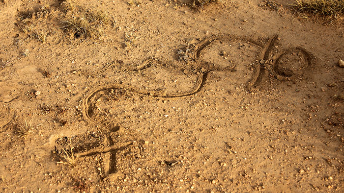 Sometimes the best directions are drawn in the dirt.
When the cowboys arrived at the cabin, Phillips got off his horse, picked up a stick and drew a map in the sand to a pasture gate where they would bring the cattle. I took a photograph with my cell phone for reference, and sure enough, Phillips’ detailed drawing in the road led me to the right place. It wasn’t long before cattle started sifting through the gate, followed by the cowboy crew, and I was there, ready to get the shots.